General introduction to the Emission Register project
Contents
Scope of the project
The Emission Register contains the yearly releases of more than 350 pollutants to
air, soil and water. The Emission Register project covers the whole process of collecting,
processing and reporting of the emission data in the Netherlands. The emissions from
individual point sources (companies or facilities) and the diffuse emissions, calculated
from national statistics by the so called task forces)
are stored into one central database.
Top
Goal
Goal of the project is to agree on one national data set for emissions that meets
the following criteria: transparent, complete, comparable, consistent and accurate.
This data set is stored in a central database, from which all the national and international
reporting is done.
Top
History
The first steps for the establishment of an integrated Pollutant Release and Transfer
Register (PRTR) were taken in 1974 in the Netherlands. Following on from ICT developments,
several updates of the database application have been performed since then, including
a close integration with GIS. The components for each compartment (air, water, soil)
were identified with respect to the nature and seriousness of the environmental
problems, the sources and the location of the sources. Later, the dimension ‘time’
was added to allow a focus on trends. This resulted in an Emission Register with
five dimensions:
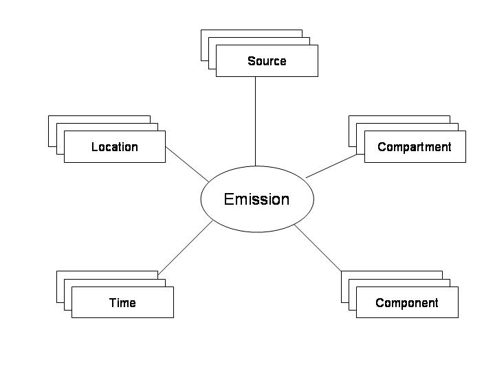
Figure 1: Dimensions of emissions in the central database
Top
Organisation
The National Institute for Public Health and the Environment (RIVM) co-ordinates
the annual compilation of the Emission Register on behalf of the Ministry of Infrastructure
and Environment. The Emission Register was established in co-operation with a number
of institutes, including Statistics Netherlands (CBS), the Netherlands Organisation
for Applied Scientific Research (TNO) and Deltares. In total about 70 persons are
involved.
(The page related links lists the organisations
participating in the Dutch Emission Register)
Top
Operating Procedure
Collecting and processing national emissions for each emission source is performed according
to a standard protocol. Different emission experts from the participating organisations
in the task forces calculate the national emissions from
700 emission sources on the basis of these protocols.
A formal agreement is drawn up by all the participating organisations. After intensive
checking, the national emissions are accepted by the project leader of the Emission
Register and the data set is stored in the central database located at the PBL Netherlands Environmental
Assessment Agency. Here the national emissions are spatially
allocated per emission source.
Top
Task Forces
The 700 emission sources are logically divided into about 50 work packages. An emission
expert is responsible for one or more work packages, the collection of the data
and the calculation of the emissions. The experts are also closely involved in developing
the methodologies to calculate the emissions. Work packages are grouped into 6 task
forces as described below:
Task force on Energy, Industry and Waste Management - ENINA
This task force covers the emissions to air from the sectors Industry, Energy production, Refineries
and Waste disposal. ENINA has emission experts from the following organisations:
The National Institute for Public Health and the Environment, PBL Netherlands
Environmental Assessment Agency, the Netherlands Organisation for Applied Scientific
Research TNO, Statistics Netherlands, Netherlands Enterprise Agency and Fugro.
Task force on Transportation
This task force covers the emissions to soil, water and air from the transportation sector (aviation,
shipping, rail and road transport). The following organisations are represented
in this task force: The National Institue for Public Health and the Environment, PBL Netherlands Environmental Assessment Agency, Statistics Netherlands, Rijkswaterstaat Environment,
Deltares and the Netherlands Organisation for Applied Scientific Research TNO.
Task force on Agriculture
This task force covers the calculation of emissions to soil and air from the agricultural sector,
land use and Forrestry. Participating organisations are:
The National Institute for Public Health and the Environment , PBL Netherlands
Environmental Assessment Agency, Wageningen Environmental Research, Wageningen Economic Research, Statistics
Netherlands and the Netherlands Organisation for Applied Scientific Research TNO.
Task force on Water - MEWAT
In the task force water the emissions from all sectors to water are calculated. Rijkswaterstaat Environment, Deltares, The National Institute for Public Health and the
Environment, Statistics Netherlands and the Netherlands Organisation for
Applied Scientific Research are represented.
Task force on Consumers and other sources of emissions - WESP
This task force covers emissions caused by consumers, trade and services. The members are emission
experts from PBL Netherlands Environmental Assessment Agency, Netherlands Organisation
for Applied Scientific Research TNO and Statistics Netherlands.
Task force on spatial allocation
The task forces mentioned before focus on calculating and estimating emissions on a national scale.
This task force calculates spatial allocation within the Netherlands and advises on how these
calculations can be done in the best possible way. More information on this can be found
here. The task force consists – on behalf of the others task forces - of
representatives from The National Institute for Public Health and the Environment, PBL Netherlands Environmental Assessment Agency, Netherlands Organisation
for Applied Scientific Research TNO and Wageningen Environmental Research.
Top
Components
The Emission Register contains the emissions of more than 350 pollutants. Components
are selected according to the international reporting obligations: the Kyoto Protocol,
the EU Water Framework Directive, the European Pollution Release and Transfer Register
(E-PRTR) and various UN and EU obligations. Additionally components
for following national environmental policies are monitored.
Top
Emission Sources
In order to follow emission trends over time, it is essential to investigate emission sources.
Main sources and activities that might cause the release of emissions into the environment
are identified before a component is added to the database. The emission sources
are categorized into the following sectors and sub-sectors relevant to environmental
policies: Agriculture, Chemical industry, Construction, Consumers, Energy production,
Nature, Other, Other industries, Refineries, Sewage and wastewater treatment, Trade
and services, Transport and Waste disposal.
The Emission Register distinguishes point sources and diffuse emission sources.
Point sources are measured or calculated for a specific location, e.g. an individual factory
or facility such as a refinery or an energy plant. Diffuse sources originate in activities
where the emission register has no fixed location, e.g. agriculture, road traffic
or small companies.
Top
Compartments
The emission register shows the emissions from six compartments:
- Air for emission to the air
- Air IPCC for only the emissions that have to be reported to IPCC,
excluding some national emissions, for example, those from international shipping,
air traffic above a certain level and CO2 from biofuels
- Soil for emissions to soil, including deposition
- Discharged load to surface waters
- Load to sewers and surface waters
- Load to sewers
Diagram for discharges to water
Not all pollutants discharged from a source will always reach the environment entirely,
because part of the load is treated in urban wastewater treatment installations (UWWTP),
transferred to other compartments and/or disintegrated by natural processes. The treated wastewater
discharged from UWWTP’s to surface water is known as effluent. The pollutants left
behind in the UWWTP are disposed off through the removal of sewage sludge. Since
some of the pollutants are thus removed or broken down (by bacteria) in the UWWTP
the ultimate burden (and load) to surface water is lower. After heavy rainfall,
stormwater may cause overflows and in some occasions the surplus of wastewater is discharged without
prior treatment directly into the surface water.
Compartment “Discharged load to surface waters” contains the discharged load,
the (net) load that actually reaches the surface water. It consists of pollutants from various routes
and transfers between compartments: discharge to water,
effluents, stormwater overflows, rainwater drains, untreated sewage, runoff, leaching and
deposition on surface waters. Inflows via transboundary rivers are not included when calculating
the net load since these sources are located outside of the Netherlands.
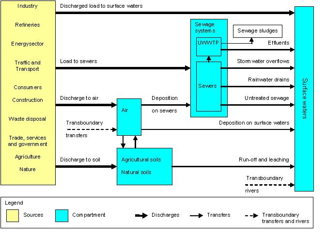 Figure 2: Relationship between the different water compartments
Top
Dataflow
The dataflow follows roughly two separate tracks: one for individual sources and
one for the calculation of the diffuse emission sources.
A few hundred facilities have to report their annual individual emissions. These
emissions are validated by the local authorities, who, in general, are also responsible
for the respective permits. The reporting is done with an online instrument: the Annual Environmental
Report (AER). These reports are stored in a central database at the PBL Netherlands
Environmental Assessment Agency. After correcting and adding some extra facilities
from other sources, the task force ENINA loads a copy of this data into the central
emission register.
The emission specialist uses various models and national statistical data originating from
the participating organisations to calculate the diffuse emissions.
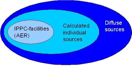
Figure 3: Sources of data in the central database
Top
Emission calculations
The individual reported emissions per facility constitute the main source of information
for the emissions of the sector Industry. The implied emission factor is used to calculate the emissions
from the facilities that do not report individually. This is carried out for each
pollutant based on the facilities that report emissions and their production. Given
the production per industrial sector the emission are scaled up to national level.
For the non-industrial sources of emissions the calculations are based on the following general principle:
Emission = Activity level x Emission factor (E=A*EF)
Data on Activities are based on national statistics. Emission factors are derived from
measurements and calculations of a model or (the international) literature. You
can find more on the calculation of emissions in the documentation.
Top
Taks force on spatial allocations
The task force on spatial allocation is responsible for maintaining and improving the
spatial allocations used by the Emission Register. Specifically it is tasked with:
- Realizing improvements in spatial allocation, by providing expertise and insights
from other task forces and regional experts. These improvements are made in collaboration
with other task forces.
- The annual analysis and evaluation of spatial allocated national emissions
- Managing the annual improvement schedule and prioritizing subjects.
- Managing the questions pertaining spatial allocation and plans for improvement from
both within the Emission Registry project as without.
- Supplying spatial environmental information to local government bodies, so they
can supply us with more detailed information about their area.
Questions pertaining spatial allocated emissions can be sent with the contactform. Twice annually a meeting is held informing interested
parties on activities and progress. More information about spatial allocations used
by the Emission Register project can be found
here.
Spatial allocation of emissions
The calculations above mentioned result in a
national total for each emission source. However, this website also shows maps
with the emissions per municipality, province, water catchment area, 5 x 5 km or 1 x 1 km grid
cells. In some cases (eg. NH3 to air, nitrogen, phosphate and heavy metals to water) the presented allocation
is the result of spatial models outside of the Emission Register. Otherwise, proxy data are used that resemble the actual
distribution as close as possible, such as traffic intensity (car kilometres) for the emissions from road traffic,
land use (surface) for agricultural emissions or population density for the emissions
from households. At this moment, there are about thirty-five allocation keys available, each of them described in a
factsheet. For industrial emissions the approach taken is different. Individually reported emissions, which have a
known location, are subtracted from the national total for the industrial sector applicable. The rest are distributed according
to the number of employees per facility in this particular sector. A sector is identified by its NACE code.
Allocations on a less detailed level (municipalities, catchment areas) are derived from the more detailed ones
(gridcel, water-discharge unit) through a geographic information system
or GIS. See the figures below for examples.
The final result shown on the map is adequate for a national and regional overview, but
not detailed enough to be used in local modelling.
Examples of allocations used:
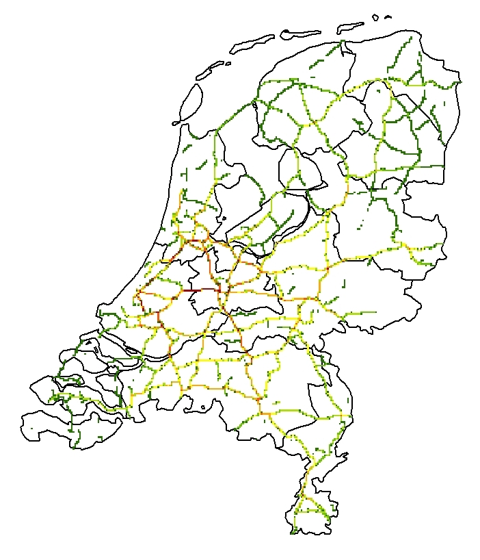
Figure 4: Relative allocation of NOx to air per km2, passenger
vehicles on highways ( > 100 km/h) (2011, red represents higher emissions)
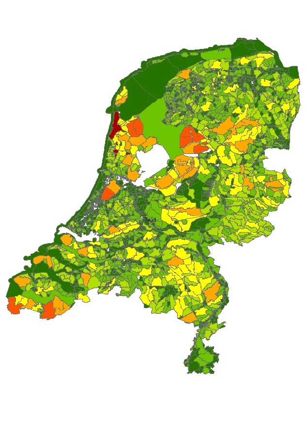
Figure 5: Relative allocation of the flushing of nitrogen per GAF_90-nl area
(2011, red represents higher emissions)
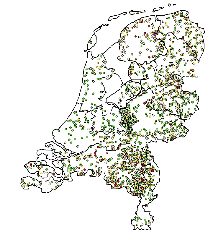
Figure 6: Distribution of poultry farms based on
GIAB.
(2011, red represents higher number of poultry)
Top